Category Archives: USA

Observations on Americana

I’m not inspired to write this entry. I’ve moved on to thinking about the next trip, and these last little bits are just so random that it makes any remotely coherent writing nearly impossible. But, this could be the last Yellowstone entry, which is great because I already have so many other things to include. Here are the last observations from our half-way across the country road trip.

Buffalo crossing signI was so happy to find the Buffalo Crossing sign to add to the photo collection! In all of Yellowstone, there is only ONE that we saw. The irony is that there wasn’t a buffalo for miles around the sign; they most certainly were everywhere else. We found the sign as we were leaving the park on the last day. Road signs included, there are quite a few differences between Canada and the US that are easily noticed when driving through the United States. None of these differences is a bad thing (well except for one which we’ll get to!)

M sign Overt Patriotism abounds in the US. Not to say that Canadians aren’t patriotic, we just don’t generally plaster the Canadian flag anywhere and everywhere (well, except in Falkland. Maybe they’re a little nutty?). In addition to flags everywhere, each little town along the way had a huge letter on a hillside somewhere on the edge of town, like a teeny tiny Hollywood sign to celebrate the town, but with only the first letter. I can’t remember where the photo of the M is from, but you get the point.

Wade Magers and Jesse Allen Another difference–elected law enforcement. In BC, Sheriffs serve primarily with the court system. They’re involved with jury selection and with transporting prisoners to court cases etc. Whereas, in the US, the Sheriff is seen as the highest member of law enforcement, and is elected by the county he/she serves. As you can see, Wade Magers and Jesse Allen were running for Lincoln County Sheriff** (Kudos to you Wade Magers for winning by over 1000 votes.) Which also brings about the use of the word “County”. Seriously, I bet less than 1 in 10 Canadians could tell you which county they live in. We never use that term. Ever.

The one sick difference–white gravy at breakfast. Biscuits and gravy=wrong! You would be hard pressed to find that in any breakfast/brunch buffet in BC. Vile! And non-sweetened Iced Tea–why would anyone want plain, tasting-like-newspaper-ink actual cold brewed tea?

testy festy
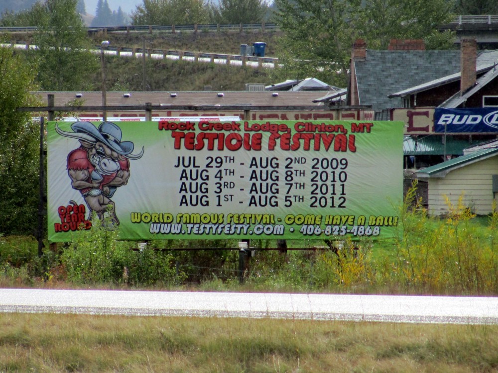
We did see another food item that was particularly interesting. Anyone up for attending the Testicle Festival event next year? Their slogan “You’ll have a ball! If you miss it, you’re nuts.” Klassy with a capital K.
And there were plenty of “interesting” attractions in the small towns we drove through. How about the Jackalope Exhibit?

adopt a highwayThere were literally thousands of Adopt a Highway signs. Every 2 miles for thousands and thousands of miles. I felt like I was being brain washed. Somehow they aren’t as noticeable here. The other uber-depressing marker that there were thousands of–little white crosses along the interstate that mark where someone has died.

And my all time favourite=Smokey Bear. I’ve never seen Smokey used on any fire prevention signs here. That would be awesome, and much more entertaining.
Smokey Bear

Happy Travels,
~j

**The campaign signs were everywhere. Jesse Allen Lincoln County Sheriff became quite the conversation topic. Imagine a made for TV movie staring Tom Selleck as Jesse Allen and some washed up wrestler (like the dude who was a Governor) as Wade Magers. They would have rival moustaches. Ooh, that would be good TV for the ancient demographic.

Wyoming: Grand Teton National Park

The TetonsEntry to Grand Teton National Park is included with the Yellowstone entry fee. Since, we had to drive through the park on the way back from Devil’s Tower we wanted to check it out. The photo above pretty much sums up the whole experience. Yep, a mountain range. The Teton mountain range. It is beautiful, akin to anything you’d see in Banff or Jasper, but just not quite as spectacular.
If you have experienced the moment when you’re driving, and Mt. Robson is just around the corner, it is a perfect blue sky day, and all of a sudden you’re in the Canadian Rockies, then you know what I mean. The Tetons were gorgeous, they just didn’t create that same sense. (FYI: Grand Teton is the highest point on the left side of the photo.)

Do Not Feed Prairie Dogs

Do not feed prairie dogsPrairie Dog Town is a real location at the entrance of the Belle Fourche campground. True story. Check out the map. We ended up spending a very rainy night there. The campground was nice enough, but the weather not so much. At least we were able to take some fun photos.

This slideshow requires JavaScript.

 These Black-tailed prairie dogs remind me of the marmots at one of the parks here. (photo below) Even though they’re Yellow-bellied marmots–they still look the similar. Yep, Groundhogs, Marmots, Prairie Dogs, whatever you like to call them–the same all over the place. (ps: they really are all from the Sciuridae family, so there’s your mini science lesson for the day.)
gopher


Devil’s Tower

Devil's TowerIn 1906, Devil’s Tower was proclaimed the first national monument by President Roosevelt. The tower is a crazy rock formation. From the pictures it doesn’t really look that big, but the top of the tower is about the size of a football field. Though it looks like an old volcano it isn’t.

The tower is actually an igneous intrusion (Science lesson: Magma pooled under sedimentary rock, it eventually hardened and then the sedimentary rock–being softer, eroded over time and exposed the igneous rock formation of the tower. Munson would be so proud of me remembering all of that from Geography!) Now this I had to use google for: “Devil’s Tower is made of Phonolite porphyry, it is similar in composition to granite but lacks quartz. Phonolite refers to the ringing of the rock when a small slab is struck, and its ability to reflect sound. Porphyry refers to its texture, large crystals of feldspar embedded in a mass of smaller crystals.”

Sad to say that the tower was pretty amazing, but this was probably one of the worst parts of the trip. We drove half way across the country so that Jon could climb at the tower and I could tour the park. But this was the only day of the whole trip that it wasn’t scorching hot. It RAINED so hard that there was no climbing to be had by anyone for the day we paid for, or the day after that. SO HORRIBLE! So, now Jon has a credit in Wyoming for the next time we happen to feel like driving over 2000km and back just for the weekend.

Wyoming: The Road Kill State

I don’t even know where to start with this entry. Maybe with some photos…

After we had driven through miles and miles of corn fields in Montana, the scenery in Wyoming was a welcomed change. Luckily, we managed to take the scenic route to Devil’s Tower which made a lot of difference. Most of these shots were taken from a moving vehicle, so don’t be too sad if they’re off kilter.

This slideshow requires JavaScript.

We drive major highways all the time. Every day. Hwy 1, Hwy 5, Hwy 16, Hwy 97, etc etc. Even including all the driving in other countries, the number of times I’ve seen road kill prior to this trip is probably less than 20. In Wyoming, that number is probably about 1500, and I’m not exaggerating. Why the hell is there so much road kill on the I-90? So disheartening.

Bet you really wanted to know this—in many States and Provinces it is legal to collect and eat road kill. Seriously. Animals are collected (if they’re not too smashed up) and distributed to churches, soup kitchens etc to make meals. People can keep the meat they find; different rules apply in different areas though. I suppose it makes sense? At least you know how and where the road kill happened to be if you’re the one who hits it? Is it really different than hunting game? The animal is still being killed, just with a vehicle, not a conventional weapon? But somehow I don’t think I’ll be trying roadkill stew any time soon.

Wikipedia even has a nutritional values chart. Yummy.

Yellowstone to Cody

Yellowstone SunsetEarly evening on day 3 of the trip we left Yellowstone through the East Entrance. We drove through the Shoshone National Forrest and ended up in Cody, WY for the night.

Cody is a small place just under 10 square miles (25km²) with a population of almost 9000. AND, the Walmart is open 24/7. How is this physically possible? We have more than 10 times the population and Walmart still closes at 10pm. I guess the demand just isn’t happening here!

How is this even necessary?!

And, the other difference, try not to vomit, you read that correctly. FIFTY! Who needs 50 McNuggets?!? (FYI: I’m willing to bet a 10 piece meal here is almost that much.)

Walmart and Nuggets aside, I really enjoyed Cody. It was an immaculate little town–so clean and beautifully landscaped. Before we shipped off to our next destination we went to the Buffalo Bill Historical Centre. (Not the “It rubs the lotion on its skin” Buffalo Bill, just so we’re clear!)

Cody is actually named after William Frederick Cody aka Buffalo Bill. Wild West history isn’t really something I’m into or very well informed of, but Buffalo Bill seems like a hip dude for his day. He worked for the Pony Express. He was against slavery, he was for women’s suffrage, he fought for the rights of American Indians. He also wanted equal pay for equal work. He fought in the Civil War. And though he hunted buffalo, (that’s how he got his famous nickname) he also supported conservation. That’s pretty forward thinking for the times I’d say.

I for one say let us give our women absolute freedom and then it will do for us to talk about freeing other nations…I believe in Women Suffrage…I’m not one of the kind that think that God made woman to do nothing but sit at home in the ashes and tend to babies…if a woman can do the same work that a man can do and do it just as well she should have the same pay.
                                                                                                    —W.F. Cody

Buffalo Bill Historical Centre Cody WyomingThe Historical Centre is actually 5 museums in one. In addition to Yellowstone history, Plains Indians history, Western Art and Buffalo Bill history, there is a huge fire arms exhibit. I’ve never seen so many guns in my entire life.

Stay tuned for Devil’s Tower…
Happy Travels,
~j
ps: Cody has a Dug Up Gun Museum. That’s just crazy. No, we didn’t visit.

More Yellowstone

Yellowstone Walkway

Taking photos on vacation is one of my most favorite things to do. I’m learning patience when taking shots. (I could be the most impatient person on the planet!) Basically, if I don’t take time I’ll end up with loads that are blurry or slightly off centre or just not right. While I’m not stellar, I do enjoy taking as many shots as I can. They’re getting better–trust me! (Besides, I didn’t take photos professionally for 15 years of my life like Jon did.)

Luckily, Yellowstone is a living photo shoot. Everything is moving and colourful. From the massive hillsides of burnt trees, right down to the small things like stripes of cyanobacteria in water, or steaming blue pools of water, there were so many things to take photos of.

This slideshow requires JavaScript.

Stop, Drop, Roll

Naturally Reseeded by Wildfire
Reseeded by Wildfire in 1988

The park covers 8980km² which is about 2.2 million acres. In 1988 almost 800,000 acres burned. Thousands of fire fighters and 380 million litres of fire retardant were used for one of the largest fire fighting efforts ever, and still it was Mother Nature that eventually squelched the fire with fall rain and snow.

Yellowstone, and the National Park Services have a natural burn policy–as long as a fire is caused by nature (ie: lightening) and isn’t threatening human life, park structures, natural resources or areas of cultural importance the fire is allowed to burn. Obviously fire is important to the ecosystems of the park; I can appreciate that. Allowing 36% of the park to burn in 1988 certainly affected the landscape we saw. One can’t help but wonder what the deforested areas would have looked like had there been no mass fire. It isn’t as though we’re strangers to the scorched earth landscape left behind by wild fires–BC is always on fire. Always. On the positive side, the 20 year old trees appear to be thriving and green where they’re growing back.

Dead trees, YellowstoneAnother tree oddity on Cooking Hillside–“Shake then Bake”. From one of the sign posts: “Covered by dense forest until 1978, this hillside changed dramatically after a swarm of earthquakes struck the area. In spite of being jolted again and again, the trees remained standing, but met their demise soon afterward when ground temperatures soared to 200°F or 94°C! Roots sizzled in the super-heated soil and trees toppled over one by one as steam rose eerily between the branches.”

Some more park facts for you:

Yellowstone Lake is one of the largest high altitude lakes in North America at 2557m above Sea Level. (Or, 7733 feet.) Yellowstone Caldera is the largest super volcano in North America. We crossed the continental divide several times while in the park. Most of the park is in Wyoming, but also there’s 3% in Montana and 1% in Idaho. This Map shows the Caldera, the Continental Divide as well as all the roads and other normal map components. It is almost identical to the one given out at the park entrance.

Yellowstone Lake

Moving from flora to fauna, in 1926 Wolves were nearly exterminated in the park. By the 1970’s the Wolf was on the US endangered species list. In 1995, and 1996 there was a successful Wolf reintroduction program. To promote bio-diversity, 32 wolves were imported to Yellowstone from BC and Alberta. Word is that the wolves “were back” when we were in the park. Loads of people with spotting scopes were at pullouts in the Lamar Valley. One couple we ran into (who said we had Canadian accents, and that they aspire to be Canadian because “we’re so civilized”–so funny!) had been successful in their viewing that morning. They have lived near the park all their lives, and were super excited to share information with us.

Once they had been watching a small wolf pack for days (can’t remember the pack name, but they knew exactly who they were), they saw the wolves take down a bull Elk, and then a Grizzly came and stole the carcass. They said they whole thing went on for about 3 days until loads of people showed up with scopes and binoculars to watch. We did not see anything even close to that, but then again, we didn’t have days to sit in one spot in hopes of seeing something with binoculars.

I did manage to spot some things with my eagle eyes, and thanks to my new camera I did get photos. These shots were taken from super far away, but you still get the gist. ps: I love the little goat peeking out from his leafy snack a top a cliff in the middle of nowhere.

Old Faithful

We arrived about 15 minutes before an eruption of Yellowstone’s famous Old Faithful. Eruptions occur anywhere from 65 to 91 minutes apart with a 10 or so minute window either way, so we were lucky we didn’t really have to wait. Word is that if the eruption lasts less than 2.5 minutes the next one will be in 65 minutes or so, and if the eruption is longer than 2.5 minutes the next one will be in about 90 minutes. So clever those scientists making a schedule for everyone!

Old Faithful is totally the “Mona Lisa” of the Yellowstone. You can’t really visit without seeing it, but it isn’t the most beautiful feature. And, it is by far the most touristed. There were hundreds of people waiting to see the show–half probably on bus trips to see one or two things in the park and then off to their next destination. Oddly, when we were getting our info at the Yellowstone Association, the two guys who were behind us said, “We have 3 hours–what do we see?” How about a whole lot of nothing!

Surprisingly, even though it is most famous, Old Faithful isn’t the highest or largest geyser in the park. Steamboat Geyser (video in previous entry) takes that title. However, unlike Old Faithful, Steamboat is unpredictable with major eruptions from 4 days to 50 years apart. Old Faithful is usually around 145 feet high, whereas Steamboat has been up to 300 feet high. Last huge Steamboat Geyser eruption was in May 2005.

Here are the Old Faithful photos. Imagine you have a flip book.

This slideshow requires JavaScript.

I’m sure the Old Faithful Inn and Visitor Info Centre go through periods of boredom and super busy insanity every 45 to 91 minutes. There was mass exodus once the eruption was over. Obviously, it was worth seeing, but not the most spectacular thing we saw in the park.

Happy Travels,
~j